The smallest state and why it's getting smaller
http://stories.usatodaynetwork.com/risingthreat/wp-content/uploads/sites/153/2019/12/1013222742-ri_pvd_Block-Island_01.jpg
NEW SHOREHAM — With each storm, another layer of the Block Island landfill washed away.
Weather-beaten tires, chunks of concrete and twisted metal emerged from its disintegrating face. Broken bottles and rusty cans spilled down the bluff onto West Beach below.
One nor’easter in 2011 unearthed a ramshackle sedan, the top sheared off but its bottom intact, seemingly parked in the wet slope. In the wake of Superstorm Sandy the following year, the marine debris nonprofit Clean Bays removed more than 10 tons of junk from the shoreline.
Closed three decades ago after more than a century of use, the landfill was partially capped and sealed off with a chain-link fence. And although it was near the beach, it was set back far enough that no immediate threat was apparent.
But as storm after storm swept through, the shoreline eroded, creeping backward under the relentless forces of nature. The fence toppled first, consigned to the trash it once stood over, and then the dump itself started a slow, inexorable collapse.
Last year, the town started building a $2-million seawall across the landfill to shield it from the encroaching waters. The boulder-and-earth wall should help, but nobody expects it to offer permanent protection.
“The site will continue to erode,” says Grover Fugate, executive director of the Rhode Island Coastal Resources Management Council. “It’s just a question of how fast.”
Kim Gaffett, former first warden of the New Shoreham Town Council and a lifelong Block Islander, puts it in starker terms.
“The land is going to give way,” says Gaffett, a naturalist with The Nature Conservancy, and the ocean will take over.”
Not so long ago, the conservancy named Block Island one of a dozen “Last Great Places” in the Western Hemisphere, celebrating work that has protected nearly half of it from development.
But protecting Block Island from the power of the ocean may prove a more intractable challenge. The wind-whipped patch of land, which sits 12 miles off the Rhode Island coast, has some of the highest rates of erosion in a state prone to erosion.
Normal wave action has an effect, but coastal storms are the real drivers of change. Scientists expect them to become more frequent and more powerful as the planet continues to warm.
Sea-level rise is only adding to their impact, pushing storm surges higher, extending their reach inland, and amplifying their ability to tear away at the shore. With higher seas, even weaker storms could do heavy damage.
And so erosion is only expected to speed up with the passage of time — not just on Block Island but all along Rhode Island’s 420 miles of shoreline.
Our coasts are locked in a constant state of flux, the contours of beaches, bluffs, headlands and marshes shifting with waves, winds and tides.
Coastal erosion is not a gradual process. It's episodic, dependent on periodic instances of violent weather. A shoreline may lose two feet in one year, 10 the next. It may stay in place year after year. And then one big storm strikes and a coastal feature gets shoved back 15 feet in one go.
In the 150 years that scientists have measured changes along the New England and mid-Atlantic shoreline — regions where seas are rising faster than nearly anywhere else in the world — more than two-thirds of beaches have lost ground, according to a 2011 U.S. Geological Survey study.
Eighty-four percent of the 1,136 coastal points observed between South Dartmouth, Massachusetts and Napatree Point in Westerly are edging inland, the study found. The average annual rate of erosion in Rhode Island is 1.9 feet, according to the state coastal council.
Even though some parts of the Rhode Island shore expanded from the 1930s to the 1950s, there has been a steady pattern of loss since that has far outweighed any temporary gains.
The state is low-lying and flat and large stretches of its coast are composed of loose deposits of sandy outwash. Those conditions, combined with its geographic location, put Rhode Island in the cross hairs for erosion. The land from Rhode Island’s south shore to Cape Cod is exposed to both hurricanes and nor’easters, the most destructive storms that drive change, according to Janet Freedman, geologist with the state coastal council.
There are hot spots for erosion, such as West Beach on Block Island or Napatree Point in Westerly. The most notorious is the Matunuck headland in South Kingstown, where the shoreline is moving back by 4.7 feet a year, the highest rate in Rhode Island, and where the nearby beachside village has struggled for decades with attempts to protect itself.
But it's a mistake to think the problem is limited to the south shore.
“There’s erosion all over the state,” says Freedman.
Along Narragansett Bay, in waterfront neighborhoods like Conimicut Point in Warwick, derelict foundations peek out from the sand where houses used to stand. On the other side of the Bay, Barrington Beach is edging back. So, too, are the Quidnessett section of North Kingstown further down the Bay, and, on the Sakonnet River, Sapowet Point in Tiverton.
"It happens at a different scale than the south shore, but it is happening," says Bryan Oakley, associate professor of environmental earth science at Eastern Connecticut State University.

The Rhode Island shoreline is susceptible to change because of the way it was shaped in the last ice age.
At its maximum extent some 26,000 years ago, the Laurentide ice sheet stretched over Canada and the northeast United States, its terminal edge extending across Long Island, Block Island, Martha’s Vineyard and Nantucket. In places, it was thousands of feet thick.
The glacier advanced like a bulldozer, carving out deep channels in the ancient river valley that would become Narragansett Bay and leveling rocky hills that would become islands. As the earth warmed and the ice crept back, it left behind a lake fed by melt-water rivers that carried sand and gravel around its shores. As sea levels rose, the lake filled with salt water to create the modern Bay.
Along its southern edge, the glacier dropped piles of rock and sand to form a moraine, or ridge, from which Block Island emerged as the ice melted. The glacier’s retreat stalled around the south shore of Rhode Island and it unloaded a mix of boulders, sand and clay known as till to form high headlands. Huge chunks of melting ice created depressions between them.
As part of a phenomenon called longshore drift, waves and currents carried smaller sediment along the shoreline to create barrier spits between the headlands and seal off what became salt ponds behind them.
Something similar happened at the southeastern end of Aquidneck Island, where beaches filled in the waters around Sachuest Point, and on Block Island, too, which was once a pair of islands bisected by a glacial channel that would become the Great Salt Pond.
The natural cycle carried on for thousands of years as waves and storm surges rolled over the spits, depositing sand in overwash fans and wearing away at the headlands. Their action gradually pushed the shoreline higher and inland.
That process is continuing to this day -- indeed, speeding up -- but intensifying construction along the shoreline in recent generations has drawn a line in the sand. With beach houses, businesses and roads built close to the water’s edge, there’s no room anymore for the shoreline to migrate. Moreover, jetties, bulkheads, seawalls and other protective structures are interfering with the normal movement of sediment.
Instead of shifting backward and being replenished, coastal features are narrowing, squeezed between the competing forces of human development and natural erosion.
A grey seal looks on from the ocean as Jules Craynock and Cathy Joyce demonstrate how they track erosion on Block Island.
They stand in front of a marker at Wash Pond, just north of the island’s closed landfill overlooking West Beach. Craynock holds upright a numbered measuring stick connected by a string to another held by Joyce. By lining up the two sticks, Craynock is able to eyeball the elevation difference between them.
“14 centimeters,” he calls out.
It is just one data point that can be added to dozens of others to create a cross-section profile of the shoreline running from an inland marker to the intertidal zone. When compared over time, these profiles can be used to monitor long-term changes to the shoreline. Craynock, a retired oceanographer with the National Oceanic and Atmospheric Administration, and Joyce, a retired Yale scientist, are part of a team of a half-dozen volunteers on the island working with Oakley, of Eastern Connecticut State, to collect measurements using what’s known as the “modified Emery method” at eight sites on the island, four times a year.
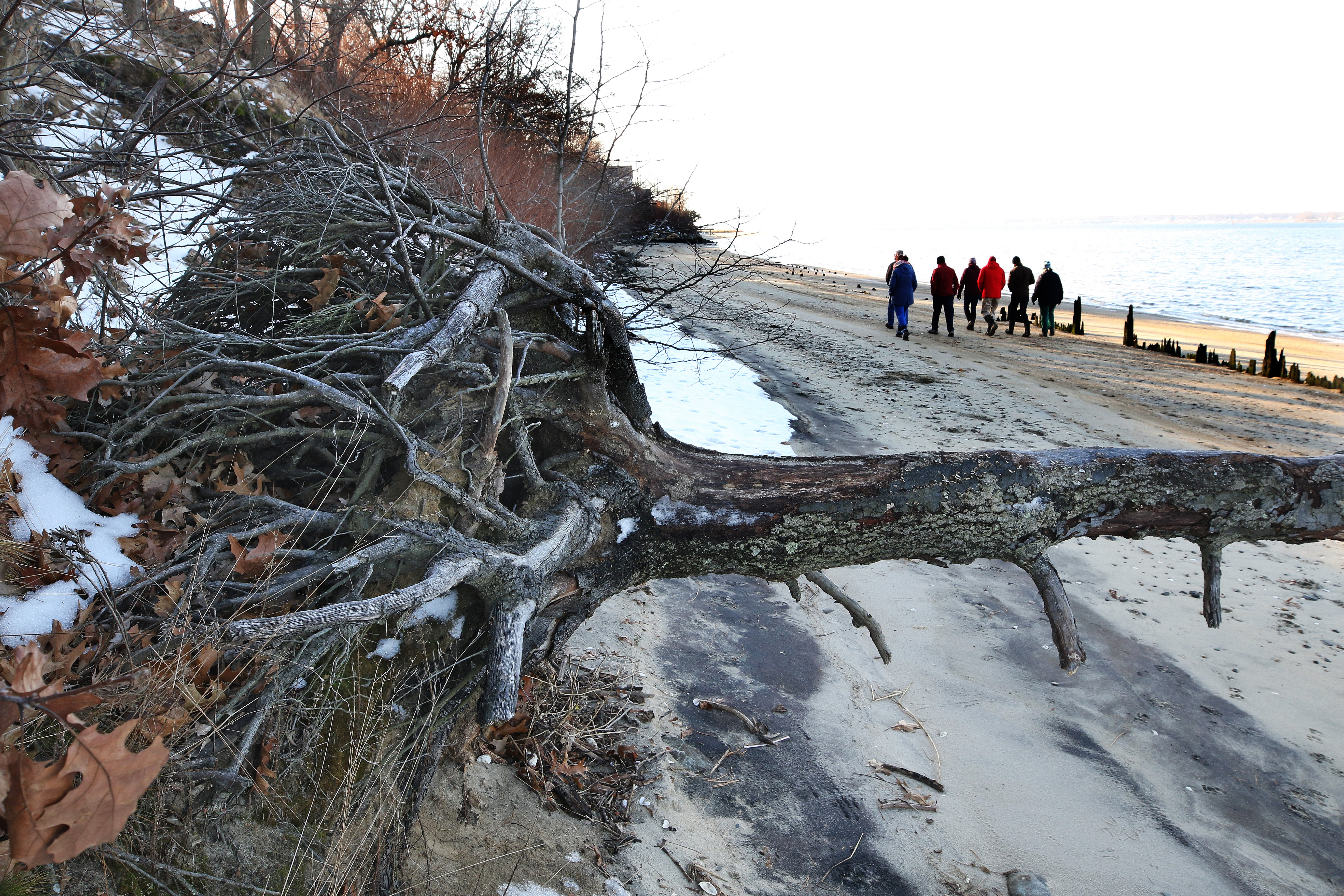
Joyce was last here about six months ago, and in that short time a steep bank has been worn down to a gentle slope, exposing car wheels and other detritus disgorged from the nearby dump. She gestures at a clump of organic material that looks like peat.
“That’s stuff that wasn’t visible before,” she says.
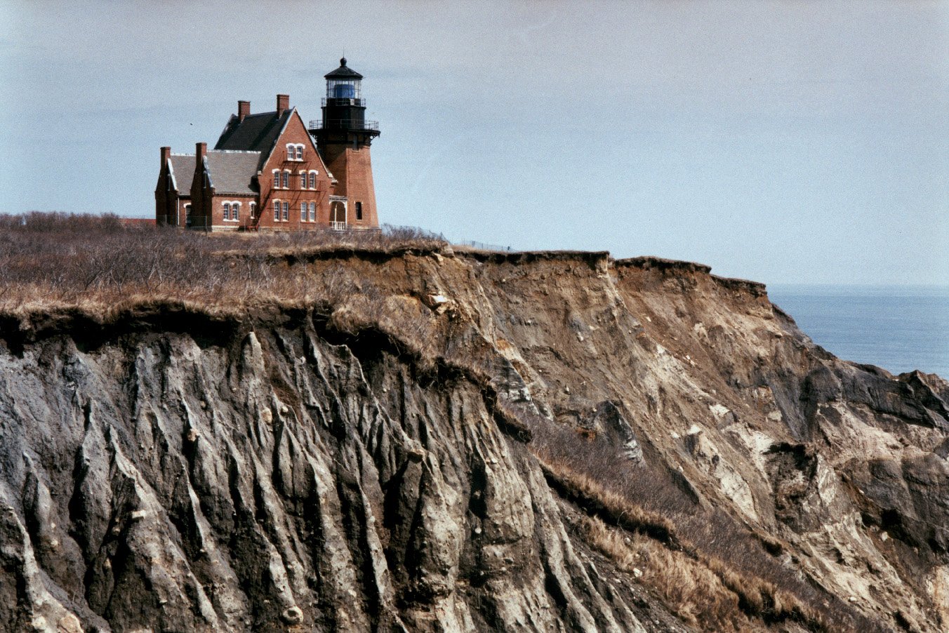
Block Island is no stranger to erosion. Famously, a group of islanders banded together in 1993 to move the historic Southeast Lighthouse inland after generations of storms had sheared away the bluff behind it. Tellingly, there was another major slump in the bluff there earlier this year.
The 10-square-mile island was created by two glacial drift sheets, one deposited by the Laurentide and another that is thousands of years older. The late geologist Les Sirkin, in his book “Block Island Geology,” described the island as a “mass of gravel” atop clay and sand on a bedrock base.
“Block Island formed like a dot of icing on the top of a geologic layer cake,” he wrote.
The layers can be seen along the face of Mohegan Bluffs and the other towering bluffs around the island, and help explain how they erode as part of a natural cycle. Water works between the layers, destabilizing whole sections that slough off. As these sediments fall into the ocean, they are picked up by longshore currents that feed the island’s beaches.
There is a regular process of coastal change on Block Island, as well as along Rhode Island’s south shore. Storms scour away the sand in the winter. In the spring, waves carry some of it back. Over time, however, the shoreline is experiencing a net loss.
Sea level rise is a telling factor. But there are localized causes, too. West Beach, Oakley says, is “sand-starved” probably because of a jetty at the opening to the Great Salt Pond, which divides the southern mass of Block Island from its northern reaches.
A permanent breachway connecting the pond to the ocean wasn't dug until 1895. Ten years later, the U.S. Army Corps of Engineers lengthened the jetty on the south side of the breachway so it extended a third of a mile from shore. The rubble structure impedes the natural south-to-north drift of sediments from the island’s western bluffs. Currents shed more of their load at Charleston Beach just south of the jetty and still hit Sandy Point at the far northern tip of the island, but they largely skip West Beach.
The effects are evident in erosion maps created by Oakley that are based on aerial photographs of the shoreline. From 1952 to 2016, Charleston Beach grew 160 feet wider, but the section of West Beach in front of the Block Island landfill moved back 106 feet. Stretches just to the north lost twice that much. The highest rates of erosion on Block Island are found on West Beach.
“All shoreline protection structures have consequences,” Oakley says.
With its waterfront location and sweeping views of Block Island Sound and mainland Rhode Island beyond, the bluff atop West Beach seems an unlikely place for a garbage dump.
The land was donated to the town, says New Shoreham Town Engineer Jim Geremia, which offers some explanation. The location may also have been chosen because in the late 1800s there would have been few homes nearby to be bothered by the smell of sewage sludge dumped there, says Mark Dennen, supervising scientist with the state Department of Environmental Management’s Office of Waste Management. It was also a time when wetlands, both coastal and riverine, were regularly used as dumping grounds.
After the heavy damage sustained in Superstorm Sandy, New Shoreham town officials realized they had to do something about the eight-acre site. Their first choice was digging it up and hauling the contents to the Central Landfill in Johnston, where the island’s garbage currently goes. It was the option preferred by the state coastal council.
But the logistics of getting things to and from the island by ferry can be maddeningly difficult. With an estimated price-tag of $20 million, removing the landfill was determined to be unaffordable for the island’s 1,000 or so year-round residents.
The town instead sought to protect it with some type of seawall. Plans to use “geotextile” bags filled with sand or a hybrid system that would have paired them with stone were also deemed too costly, so engineers settled on a stone wall and went to the coastal council in 2016 to seek permission.
The council generally forbids the construction of hard structures near the water because of the damage they can cause to surrounding areas. Most existing structures predate current regulations. In only rare cases in which a public need can be demonstrated does the council allow new shoreline hardening. They include Matunuck village, where a decade ago a proposal for a steel seawall to protect a coastal road gave rise to lawsuits and a cascade of other schemes to armor the shoreline.
The council approved the first phase of the wall fronting Matunuck Beach Road in 2012 and just last month voted in favor of a second phase, in both cases ruling that protection was necessary because the road is the only way to and from 240 homes. But the owner of the Ocean Mist, a landmark tavern on the beach, raised concerns about waves deflecting off the structure and eating away at his land, so the council is allowing him to rebuild an old revetment to protect his property.
Similar issues came up with the Block Island project. A wall might protect the front of the landfill, but the shore to the north and south would continue to erode and the sides of the landfill would be exposed, council supervising scientist David Reis noted in a review of the proposal three years ago.
“It could turn out to be a peninsula over time,” he says now.
Of particular concern is the northern side of the landfill, which abuts the coastal wetlands around Wash Pond that are prone to flooding during storms and are losing the sandy barrier in front of them. Sea level rise alone will threaten the landfill from that side. With three feet of rise, water will start approaching from the wetlands. With seven feet, it will come in from the southern wetlands too, according to projections from the coastal council and the University of Rhode Island.
Describing the landfill as “the biggest threat to the ecological integrity” of West Beach, The Nature Conservancy argued that a wall would eventually fail.
“We view the current proposal as just a stopgap measure that will buy time, but not solve the problem,” associate state director Scott Comings wrote in a letter to the council.
Despite the concerns, the council concluded that the island had no other recourse. It unanimously awarded a special exception to build a wall.
To see what nature wants to do to the Rhode Island shoreline, just look at Napatree Point in Westerly.
Located at the mouth of Little Narragansett Bay, where the Pawcatuck River empties into the Atlantic Ocean, the sandy spit curves gently away from the village of Watch Hill, terminating at a bluff that marks Rhode Island’s southern- and western-most point.
Napatree was at one time dotted with 39 houses leading out to the remains of Fort Mansfield, which was built to protect Long Island Sound, then abandoned around the turn of the 20th century. The spit used to be much larger, its reach extending north to what was once Sandy Point.
But the surge from the Hurricane of 1938 washed the houses off their foundations and cut a series of breachways through Napatree. They opened wider over time and severed the point from what is now Sandy Point Island.
Nobody was allowed to rebuild on Napatree afterward. The Watch Hill Fire District took ownership of all but a handful of lots on the one-and-half-mile-long strip of land and created the Napatree Point Conservation Area. Ninety acres are now protected from development by the Watch Hill Conservancy.
With no roads or structures in the way, Napatree has been allowed to change with the natural cycle. It has shifted north 200 feet since 1939, but it hasn’t grown any smaller. Instead, it’s simply washed back over itself, carried by winds and waves, explains Peter August, University of Rhode Island professor emeritus of natural resources science and chair of the Watch Hill Conservancy’s science advisory committee.
“It’s a dynamic system,” August says while standing on a high dune that looks out over Napatree. “It doesn’t erode away. It just moves.”
Napatree’s durability was evident after Superstorm Sandy. The storm scoured the earth from the western end of the point, leaving a rocky moonscape in its wake, and stripped whole swaths of beach grass from ocean to bay in places. Napatree recovered, though. One section was pushed back 30 feet, but the grass regrew, and the dunes regained elevation.
Just as Napatree has moved, so too would other barrier beaches if left alone. Aerial photos taken after Sandy of nearby Misquamicut State Beach show blankets of sand -- 18,000 tons in all -- coating Atlantic Avenue and portions of the salt marsh around Winnapaug Pond. These washover fans would have been the beginnings of an inward migration of the beach if they hadn’t been scooped up and spread back over the beach.
The same is true at Quononchontaug Beach in Charlestown and to differing extents all along the 19-mile south shore from Napatree Point to Point Judith in Narragansett that is a collection of headlands and barrier spits.
As August and Janice Sassi, manager of the Napatree conservation area, walk along the point, they describe its rich ecology: the mussel beds on the bay side that attract terns and oyster catchers, the horseshoe crabs that come ashore to mate, the diamondback terrapins spotted around Sandy Point Island.
They stop to uncover a bronze disk that marks one of five transects where Oakley and his students are measuring changes to the shoreline. The area is closely studied because it’s the only barrier beach for miles that is free of development. The URI Coastal Institute named Napatree a “Climate Response Demonstration Site.”
Sassi and August are hopeful that Napatree is being managed in such a way that it will persist years from now. As to where it will be and what it will look like, however, they can’t say for sure.
If there’s a middle ground between walling off the coast and retreating from it, it may soon be found amid the fallen concrete slabs of failed bulkheads, scattered riprap and broken pilings on an East Providence beach.
At the base of Rose Larisa Park in Riverside, a steep bluff is crumbling onto the sandy strip that opens onto Narragansett Bay. Storm-driven waves have undercut the hillside, a score of fallen trees and countless exposed root balls evidence of their erosive power.
“You undercut the bank and then gravity just does its work,” says Freedman, the coastal council geologist.
She stands below the 30-foot-high bluff with Caitlin Chaffee, a coastal policy analyst with the council, and representatives of The Nature Conservancy and the City of East Providence. The council, the conservancy and the city are partnering on a pair of experimental projects this winter that aim to use natural elements to prevent the shore from eroding further.
The first of these “living shoreline” projects will use a stone shelf positioned in front of the bluff that will be backfilled with sand and planted with water-tolerant grasses. The goal is to create a salt marsh that will absorb the power of the incoming waves. The second project would stabilize a section of bluff with a combination of rocks, coconut-fiber logs and plantings.
Living shoreline techniques were pioneered in mid-Atlantic and southern states as alternatives to hard structures and have proven more robust in some places than concrete or stone walls. The projects in Riverside are part of a regional program being funded by the National Oceanic and Atmospheric Administration to explore how the techniques can be used in the Northeast.
The work in Riverside will be the first projects of their kind in Rhode Island that are designed to control erosion. The only precursor in the state is at Save The Bay’s center at Fields Point in Providence, where the environmental group used a similar method to create wildlife habitat.
Artificial marshes may not be effective in the lowest-lying areas that flood often. They also wouldn’t work in the most exposed areas along the south shore because the waves are simply too strong.
But Rose Larisa Park may offer the right conditions. The marsh could slow down erosion, and it could also move with the shoreline as seas rise. It could protect the bluffs as they edge back behind it, maintain a natural environment, and allow the beach in front to shift.
A hard structure, in contrast, would protect the bluff for a time, but the beach in front would eventually disappear.
If the projects are successful, elements could be incorporated along the neighboring waterfront -- where 47 applications have been submitted to the coastal council to repair or build new protective structures -- and elsewhere in Rhode Island.
“With structural shoreline protection, you’re working against nature. You’re getting reflection of all that wave energy. You’re getting scour,” says Chaffee. “We’re trying to encourage the natural processes to build the shoreline. We’re trying to work with nature.”
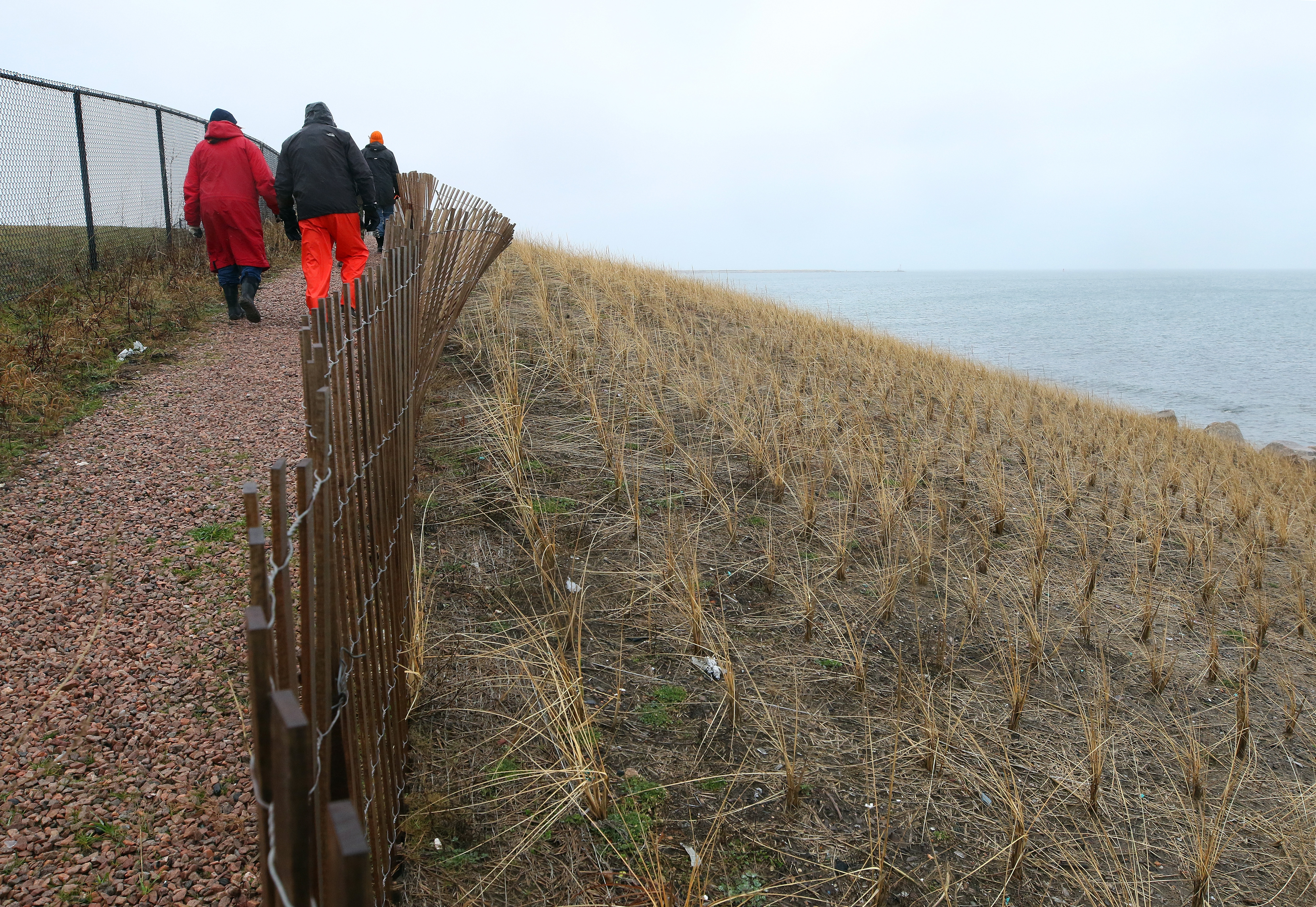
The seawall in front of the Block Island landfill was completed last spring and almost blends in with the surrounding landscape. From a row of exposed boulders, a gentle slope planted with switch grass rises up to the height of the landfill where a new fence sits well back from the edge.
Because the town lost a federal grant, the project was scaled back considerably. Instead of a stone revetment rising more than 20 feet from the shoreline, only an eight-foot-high base of three- to 10-ton boulders was dropped in place. What sits on top is a mixture of sand and soil that’s been graded to allow waves to run up its face rather than cut into it.
“It’s survived a season of storms and it’s made it so far,” says town engineer Geremia.
The original proposal was designed to withstand a storm with a 1 percent chance of happening any year -- something on the scale of Hurricane Carol in 1954. The finished structure won’t survive such a severe storm, says Fugate. The surge would crash over the wall, scour away the fill material and leave behind a mound of rubble.
The stones in the wall are simply too small, he says. Only 20- to 30-ton boulders, like those recently added to a seawall in Point Judith, are big enough to stay in place.
But even those hulking pieces of granite can be seen rocking back and forth in moderate storms, says Fugate. Transporting stones of that size to Block Island would have been prohibitively expensive and may also have been logistically impossible.
Few shoreline walls in Rhode Island have stones that are big enough. When smaller stones are dislodged, they act like battering rams in a surge, crashing through anything in their path.
And even if walls stay together, they can act like ramps for oncoming waves.
Asked if shoreline hardening gives people a false sense of security, Fugate is unequivocal.
“Absolutely,” he says.
The coastal council stands by its recommendation that the only permanent solution for the landfill is to take it out entirely, say Fugate and Reis. As part of the seawall project, the town did remove 120 tons of scrap metal and other trash, going back 50 feet, but there’s no current plan to dig up the rest.
The council has outlined the threats to the shoreline in a recently completed statewide plan that aims to help communities adapt to the coming changes. Fugate and others have described it as the only plan of its kind in the nation.
The council wants coastal communities to consider alternatives to shoreline walls. Options may include projects like those planned in East Providence that use natural elements, but at some point in time they must also include retreat.
But that, of course, is an exceedingly complex issue that touches on land rights, property values and tax revenues. It is proving a bitter pill to swallow.
"Retreat is a four-letter word around the coast," says Oakley.
In the end, Block Island did what it could with the money it had, says Kenneth Lacoste, the current First Warden of the New Shoreham Town Council. It may simply buy the island time to work on a long-term solution, or, he says, the wall may prove more resilient.
“We’ll see what happens in 15 or 20 years,” he says, “see if things pan out the way they’re predicted.”
What does the future hold for the Rhode Island shore? There are clues from past storms.
The most recent big one, of course, was Sandy, which devastated parts of Misquamicut, Matunuck, Charlestown and Narragansett. As bad as it was, a storm of the same size could be even more damaging in the future.
With seven feet of sea level rise, its surge would be as high as Carol’s, which caused $4.4 billion of damage in 2019 dollars. With eight feet, it would be equivalent to the surge from the Hurricane of 1938, which killed more than 600 people.
Both sea-level-rise scenarios are possible by the end of the century, according to NOAA.
Oakley has developed projections for higher erosion rates along Rhode Island’s south shore that account for climate change. His low calculation doubles the current rate by 2100. The high one multiplies it two-and-a-half times by 2065. There is uncertainty because the planet hasn't seen oceans rising this fast at any time in the past 6,000 years, but under Oakley's projections, a place like Matunuck could start losing between nine and 12 feet of land a year on average in a matter of decades.
In his book on Block Island published 23 years ago, Sirkin predicted that with three feet of sea level rise the island would split in two again, returning it to a form last seen thousands of years ago.
“The new shoreline would bisect Block Island: beaches would be submerged, dunes eroded, waves would be pounding against the bluffs, and the jetties that protect the harbors would be almost awash,” he wrote.
Oakley is skeptical of Sirkin's vision of the island breaking apart. The barrier beaches around Great Salt Pond should persist, Oakley argues, as long as they're allowed to shift like Napatree Point has. Block Island will continue to change but it should remain more or less in one piece, he says.
Even if Sirkin’s specific prediction for the island is arguable, a broader warning in his book may not be:
“We do not notice the change until its effects are critical.”
akuffner@providencejournal.com / (401) 277-7457